Introduction
Thorikos in Myth

The sacrificial Calendar of Thorikos
The picture offered by ancient texts and inscriptions regarding Thorikos remains fragmentary, but the town did have a role in mythology. Notably, in the Homeric Hymn to Demeter (123-128:16), the goddess is said to have come ashore at Thorikos while travelling from Crete to Eleusis.
Hesychios, a 5th-century AD lexicographer, attributed the name of the deme to an eponymous hero of whom little is known, but who is listed for regular worship in the famous inscription known as the Sacrificial Calendar of Thorikos, a stele from the late 5th or 4th century BC. Another myth, perhaps echoing a Bronze Age past, was recorded by Pherekydes in the 5th century BC: the story of Kephalos and Prokris, later told in different versions f.ex. by Apollodoros, Ovid and Antoninus Liberalis. Kephalos, king of Thorikos and known for his beauty, was married to Prokris, daughter of King Erechtheus of Athens, but the marriage was plagued by mutual mistrust. Prokris, whom King Minos of Crete had given a spear that never missed its target and a dog named Laelaps, swift as an arrow, passed these gifts on to her husband. Once, when he went hunting on mount Hymettos, she followed him, suspecting him of having an affair. She hid in the bushes to observe him, but he thought he heard an animal rustling there, threw his spear and killed his wife. Erechtheus is said to have buried her, while Kephalos was exiled and eventually committed suicide.
Historical Overview
The site of Thorikos occupies the coastal northeast of the Lavrion area or Lavreotiki, a metalliferous region of Attica, Greece. The ancient town or deme comprised three areas: a double-bay harbour by the Aghios Nikolaos peninsula, the Adami plain with the lower reaches of the Potami valley, and the double- peaked Velatouri hill, c. 144 m asl, which has seen human activity since the Final Neolithic period (c. 4100-3100 BC). The Velatouri is also the focus for the archaeological research briefly surveyed here, and presented more fully in the following sections.
The presence of a defensible hill, a viable seaport and a valley plain were all sufficient reasons for human settlement here, but there was more to Thorikos than this: its bedrock consists of layered marble and mica-schist bearing lead ores rich in silver. Mining began on the Velatouri in the Final Neolithic or Early Bronze Age, probably around 3200 BC. From the Middle and Late Helladic periods of the Bronze Age (c. 2000-1050 BC), architectural remains are extant as well as pottery and stone tools, and several significant tombs have been explored, one of which is a monumental tholos or beehive-shaped, dry-laid masonry tomb – a rare Attic example of the elite tradition known as Mycenaean. From the Iron Age, the remains unearthed so far consist mainly of graves, buildings and pottery, some of which features the characteristic decoration which gives its name to the so-called Geometric period. The subsequent Archaic period has left little behind in terms of architectural or metallurgical data, but a considerable number of tombs are extant from this time, and the pottery repertory is rich and variegated.
In the early 5th century BC, a stone theatre was built at Thorikos, and its approximate date of construction makes it one of the oldest known in the ancient world. It has an unusual, elliptical-angular shape and, like the deme of which it became an integral part, it was altered over time – monumentalized before the Peloponnesian War (431-404 BC), enlarged afterwards, and associated to assembly halls and a small temple for Dionysos. Overall, the complex archaeological record encountered at Thorikos reflects, in particular, intensified activities during the Classical period: in the 5th and 4th centuries BC, this became a remarkably multifaceted town where houses, graves, roads and shrines were juxtaposed to industrial installations such as mines, ore washeries, cisterns and towers. Sacred features, aside from the several cemeteries, include a shrine in Insula 10 and a hill terrace with carved sockets for stelai uprights – perhaps votive, perhaps funerary. Ore furnaces, however, were located off-site, near the harbour and in the hinterland. In the Adami plain, a monumental Doric stoa was built, perhaps as part of a sanctuary for Demeter. This floruit can be related generally to an increased use of silver (coin). The mines were owned by the Athenian state, and concessions for their exploitation were leased to entrepreneurs with workforces consisting of slaves and labourers, many of whom came to live on-site.
Less archaeological data has so far come from the Hellenistic period, and an important coin hoard stashed in a house in the urban area around 295 BC is commonly taken to signal an abandonment, connected to the Macedonian presence in Attica. This impression is tempered, however, by a fair amount of Hellenistic pottery and evidence of contemporary activity in some mines. In the early Roman imperial period, Thorikos was probably only sparsely occupied, but there was a new surge including prospecting and probably habitation in the 6th- 8th centuries AD, before the vivacious settlement around the Velatouri fell silent. It came to life again in the 19th century AD, when mining was resumed – and archaeological interest took hold.
A History of Archaeology at Thorikos
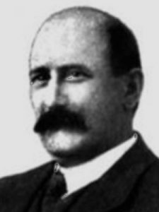
Valerios Staïs
Several topographical studies were undertaken in the Lavreotiki in the 18th and 19th centuries AD, and the outstanding features of Thorikos were explored: the stoa in the Adami plain by French architect J.D. Le Roy in 1754, the British Society of Dilettanti in 1813 and the Greek Archaeological Service in 1893; the theatre by the American School of Classical Studies in the 1880s, and Mycenaean tombs III and IV and their surroundings by Valerios Staïs for the Greek Archaeological Service in 1888-93. The Aghios Nikolaos harbour (and more) was documented by German scholars Arthur Milchhöfer and Johann Kaupert.
The harbour was also the starting point for the more recent history of archaeology here, beginning in 1960 with Herman Mussche. Between 1963 and 1989, he directed 23 campaigns at Thorikos for the Committee for Belgian excavations in Greece. The work, co-directed by Jean Servais, Guy Donnay, Tony Hackens, Paule Spitaels and Doris Vanhove, included re-examinations of the stoa (long thought to represent a temple), the theatre and the Mycenaean tombs, as well as extensive excavation of the urban area on the Velatouri and its manifold installations – the so-called Industrial Quarter. There followed two decades of intermittent surveys and soundings, and organization of the growing database; meanwhile, the stoa was excavated by Vasileios Petrakos and Maria Oikonomakou for the Greek Archaeological Service.
In 2004, new fieldwork by the Belgian School at Athens began with Robert Laffineur of Liège University and in 2006 with Roald Docter of Ghent University, initiatives which expanded into a multicollegial, interdisciplinary project under the auspices of the Greek Ministry of Culture and the Ephorate of Antiquities of East Attica. In 2010-12, industrial cistern no. 1 was excavated, and in 2012-17, a surface survey of the Velatouri was carried out by the universities of Ghent and Utrecht (Roald Docter and Floris van den Eijnde), while Denis Morin and his team from the University of Lorraine further explored the mines.In 2018, new excavations began under the direction of Docter and van den Eijnde, and a survey of the northern part of the Velatouri was undertaken by Laffineur and Sylviane Déderix of Heidelberg University. Andreas Kapetanios of the Ionian University and Roald Docter are currently re-assessing the theatre excavation results for comprehensive publication, and Johannes Bergemann and his team from Göttingen University are preparing the results from House 5 in the Industrial Quarter. A range of other contexts and assemblages is also under study and below, members of the international team present themes of current interest and aspects of their recent work.
Maud WEBSTERThorikos within the Lavrion Landscape
Landscape – geology – societies
The Lavreotiki peninsula consists the southeastern-most part of Attica in Greece. Ore and metals, harnessed by human intellect and labour, have been active in shaping this landscape on the surface and in its bowels, for millennia, consisting one of the main continuous threads in weaving their History, inextricably bounding together geology, geomorphology and societies.
Archaeological excavations have produced direct evidence, such as litharge and tools, that, at least since the end of the 4th millennium BC, silver was extracted locally from the Lavrion argentiferous ores.
Ores were originally accessible in pockets exposed at the surface, especially by the great detachment fault and folds, or at the hillsides, and processed probably in small-scale installations, invisible today. Prehistoric sites’ distribution seem to correspond to such a model. Through the centuries, locally acquired and imported empirical knowledge in understanding local geology and in developing related technology, led the exploitation deeper and scaled up geometrically processing.
Thus, in the early 5th C BC, the Lavrion mines and metallurgy provided the exceptionally strong and stable material basis for the success of the Athenian Democratic Polis (city-state), for the escalation of its naval force and its political power towards the Athenian Hegemony over many of the other Greek Poleis. The perfectness of Parthenon stands as the conspicuous material symbol of material and intellectual power founded upon the obscured 5000 hectares of dense architectural remains of the Lavrion mines and metallurgical workshops, still visible today.
Andreas Kapetanios
Κακαβογιάννης Ε. 2005: Μέταλλα Εργάσιμα Συγκεχωρημένα: η οργάνωση της εκμετάλλευσης του ορυκτού πλούτου της Λαυρεωτικής από την Αθηναϊκή Δημοκρατία, Δημοσιεύματα Αρχαιολογικού Δελτίου αρ. 90, Αθήνα.
Political and Spatial organisation

The political and spatial organisation of Athens in the 5th C BC, after Traill 1975. Coloured circles represent conventional Demes’ centres. The shaded area highlights the Lavreotiki Demes.
The Athenian Polis of the Classical Era spread over the whole of Attica and was structured in political and spatial entities called the Demes. Ancient Lavreotiki consisted of ten such demes of varying size, each one spatially organised within certain discrete geomorphological segments of the landscape, usually a plain or valley system with its outcrops and surrounding hills. The Demes’ built space was structured by scattered or clustered units/modules, each one combining production and habitation: farmsteads or metallurgical workshops. Economic practices, in their relationship with geomorphology, affected the degree of clustering of settlements that arise: Farmsteads are usually loosely scattered as arable and grazing land surrounds them. Metallurgical workshops (mainly ore-washeries for the enrichment of ore) are clustered tightly in a linear arrangement on the slopes, but also on the level parts of the valleys, their operation being inseparably linked to managing the hydrological network. These should be perceived as nodes in the Demes’ networks, also structured by extensive hydraulic works, roads, harbours, cemeteries, forts and collective foci such as sanctuaries and agoras, the centres of their collective socio-economic activity. This archaeological picture corresponds to the mental maps emerging from the Poletae Inscriptions of the 4th and early 3rd C BC, the archives of the contacts for the mine-leases.
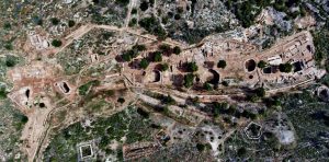
Partially Excavated ore-washeries workshop cluster (Classical period), densely and linearly arranged in a small branch of the extensive inner valley system of Souriza , which is fully built. (aerophoto: Ephorate for the Antiquities in East Attica)
From the 1st C BC to the 4th AD a process of political and economic change produced a complete transformation of the structuring of the Lavrion Landscape: instead of a Deme-model network, in the Late Roman times we identify three nucleated settlements and a largely abandoned landscape, available, though, for the systematic exploitation of the huge quantities of mining and metallurgical tailings and sub- or by- products of the earlier centuries of activities.
Andreas Kapetanios
Crosby M. 1950: “The Leases of the Laureion Mines”, Hesperia 19, 284-285; Kapetanios, A. 2013, Καπετάνιος, Α. “Ο χώρος και οι άνθρωποι στην αρχαία τοπογραφία της Λαυρεωτικής”, σε Δόγκα-Τόλη Μ. και Οικονόμου, Στ. (επιμ.) Αρχαιολογικές Συμβολές, τόμος Α, Μουσείο Κυκλαδικής Τέχνης 183-198; Traill, J. S. (1975). The political organization of Attica: a study of the demes, trittyes, and phylai, and their representation in the Athenian Council (Vol. 14). Princeton, NJ: American School of Classical Studies at Athens.
Thorikos: the osmosis between a sacred and an industrial landscape
Thorikos, apart from being a production centre, probably played an important role in the movement of metals and technology in prehistoric times. Around 1500 BC, at the dawn of the Mycenaean apex, navigators were looking for a distinctive sign on the horizon of the Attic land: three peaks, one next to the another, beaconing Thorikos’ double safe harbour. Of the three, the one in middle was artificial: a burial tumulus on the saddle of Velatouri double peak. Next to it, excavations revealed the offerings of Thorikians of Archaic and Classical times to the Heroes, their ancestors. A sacrificial calendar of 380-375 BC, attributed to the Deme of Thorikos, names Heroes and Heroines and spreads their cultic activities within the annual cycle. Among them, Thorikos and Prokris could be the ones venerated at the Peaks, whereas Hyperpedhios (the one who overlooks the plain) was worshiped in a 4th C BC shrine, adjacent to a workshop (one of a cluster) on the Stephani hill-slope, across the plain, to the West of the Velatouri.
This cultic landscape corresponds to Classical Thorikos, one of the ten Lavreotiki Demes, spreading over a complex system of alluvial valleys and its surrounding hill-slopes, following the general model of the Lavreotiki spatial organization: besides the “Quartier Industriel”, production and habitation clusters of workshops and farms, such as those of Philocrates, Kifissodhotos and Euthydhike, landmarked by rupestral inscriptions, roads and burial enclosures, the smelting workshop and the fortress on the peninsula of Agios Nikolaos, are visible today. The area of the Double doric stoa probably marks the Thorikian Agora; together with the Theatre they constitute the Deme’s Collective centre.
Andreas Kapetanios
[Andreas Kapetanios (in press): «Thorikos’ Theatre: retaining walls – retaining chronolo gies?», in: Thorikos 1963-2013: 50 years of Belgian Excavations, evaluation and perspectives, Proceedings of the conference held in Athens 7-8 October 2013]; Kakavogianni Ο. – Anetakis M. 2012: «Les agoras commerciales des dèmes antiques de la Mésogée et de la région du Laurion», in V. Chankowski, P. Karvonis (eds.), Tout vendre, tout acheter. Structures et équipements des marchés antiques, co-édition École Française d’Athènes- Ausonius, Scripta Varia 42, 185-202
The Mycenaean Tombs
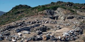
Mycenaean Tombs
The Mycenaean graves at Thorikos illustrate perfectly the evolution of tomb types in mainland Greece in the 2nd millennium BC. Their monumental character and quality of construction testify to the existence of a local elite, and some of their features and finds indicate external contacts, with the Argolid and Messenia in particular. Although all had been looted before archaeological investigation, the evidence they provide is considerable.
The earliest burial is Tomb V, on the saddle between the two summits of the Velatouri: a cist grave enclosed by a rectangular construction (7.80 x 5.80 m), covered by a tumulus and surrounded with a circular retaining wall (17.50 m in diameter). Extant offerings point to a date at the beginning of the Mycenaean era (Late Helladic I, 16th century BC). An oblong shaft near the retaining wall of Tomb V was thought to be a cult place by V. Staïs, its excavator, who called it a bothros, but it is probably a burial place. If so, it would be the third oblong tomb discovered on the Velatouri so far (see below), and I have proposed to call it Tomb VI. Middle Helladic sherds from its lower levels indicate an early date between the Middle and Late Bronze Age. Tomb IV, immediately to the north, is oblong. The chamber plan and the structure of its covering are intriguing, and without parallels in the Aegean. But the main features of the later tholos (Tomb III, below) are already present here: a circular peribolos wall (30 m in diameter), functioning both as a retaining wall and as a symbolic enclosure, and an invisible relieving triangle (of limited efficacy). Excavations yielded repoussé gold sheet ornaments reminiscent of specimens from the acropolis shaft graves at Mycenae, and final Late Helladic I pottery, probably contemporary with the construction of the tomb just before 1500 BC.

Mycenaean Tomb III
Tomb III is the only true tholos on the site. It features an invisible relieving triangle (unlike the later, 13th-century BC tholoi, the Treasury of Atreus and the Tomb of Klytemnestra at Mycenae), and a circular peribolos wall (32.50 m in diameter). The chamber walls present an inward-tilting profile and the angle value increases from bottom to top, like in tombs at Kakovatos in Triphylia and Prosymna in the Argolid. A date shortly after 1500 is indicated by grave-goods such as a Late Helladic IIA gold ornament in the shape of a figure-eight shield and an ivory pyxis or cylindrical box with running spirals in relief, with parallels at Ano Englianos (Pylos) and Routsi in Messenia. Tombs I and II, to the east and west of Tomb IV respectively, are ‘built chamber tombs’. Tomb I is oblong, with access through a short corridor or dromos, and yielded a squat alabastron of Late Helladic IIA type, stone beads and some gold jewellery. Tomb II is L-shaped, like the ‘gamma tombs’ at Eleusis, with a short dromos and a partition wall closing off the rectangular chamber. The only significant find here was a kylix (stemmed drinking cup) of Late Helladic IIIA2/ IIIB type (1350-1250 BC).

Sheet gold pendant with a butterfly in repoussé
Mycenaean tombs at Thorikos have also revealed significant evidence of practices of a mnemonic character in historical times. A low platform (altar?) leans against the external face of the retaining wall of Tomb V, and the Archaic and Classical painted pottery found in the upper layers of the tumulus is probably connected to some kind of cult honouring the deceased, who were evidently celebrated several centuries after their passing. The upper layers of Tomb I produced terracotta figurines and sherds from the 7th to the middle of the 4th century BC, and above the Mycenaean shaft, a rectangular stone plaque had been placed. Close to this, a circular shaft had been dug to receive offerings, and similar finds were made in Tomb VI (the ‘bothros’). Together with the construction skills and the external contacts evinced by the tombs themselves, such remembrance is an additional hint of the high status of the elite ruling Thorikos around the middle of the 2nd millennium BC. Their position and power probably originated from the exploitation and trade of the metal resources here.
Robert LAFFINEURThe Acropolis

Acropolis
In 1998, Herman Mussche gave an apt spatial definition of this zone of Thorikos: “When using the term Acropolis we are referring to the whole of the area above the 100 m line, as well as Mycenaean tomb no. III, which is located somewhat lower down.” This area was the main inhabited part of Thorikos from the Final Neolithic/Early Helladic period until at least the 8th century BC, with occupation continuing until the end of the 5th century BC. The survey of 2012-2015 has shown that habitation ended here by the 4th century BC, when mining and ore processing activities moved to the 10-60 m zone at the foot of the Velatouri. Already in the eighties of the 19th century, Valerios Staïs excavated both the Mycenaean tombs on the acropolis and the Early (?) through Late Helladic houses that clustered around the c. 140 m high summit. Unfortunately, these interventions were not adequately published. Tombs III and IV were re-excavated by Jean Servais of Liège between 1963 and 1972, and a new one, Tomb V, was identified and excavated. Evidence of heroic cult practices could be recognized in three of the tombs, extending from the second half of the 7th to the middle of the 4th century BC in the case of Tomb I. Servais also excavated the plateau to the east of the summit, where he discovered, in three trenches, a complex stratigraphy with architecture of the Bronze- and Early Iron Age. His excavations were only preliminarily published. Small control excavations were done in Servais’ easternmost trench in 2000 and again in 2014. A new project by a team from Louvain-La-Neuve, Liège and Heidelberg is currently re-investigating these excavations with a view to comprehensive publication.
Roald DOCTER
Mussche, H., Thorikos. A mining town in ancient Attika (Fouilles de Thorikos/ Opgravingen van Thorikos II), Ghent, 1998, 17-22; Van Gelder, K., Old excavations near the top of the Velatouri at Thorikos: A revision, in: Docter, R.F. (ed.), Thorikos 10. Reports & Studies, Ghent, 2011, 15-49; Papadimitriou, N., Ceramic material from Valerios Staïs’ excavations at the prehistoric settlement of Thorikos, in: Thorikos 1963-2013: 50 Years of Belgian Excavations. Evaluation and Perspectives, forthcoming.
The Industrial Quarter
The inhabited area on the lower slopes of the Velatouri, situated west of the theatre, is commonly known as the Industrial Quarter. This is partly a misnomer, since the area only became truly industrial by the 4th century BC. Between 1963 and 1987, the area was excavated on a large scale, the results of which were partly published in the Preliminary Reports series. While habitation had been confined to the acropolis in prehistoric times until well into the Geometric period (c. 8th century BC), a large housing quarter grew on the lower western slopes during the Archaic period. Still, in architectural terms, this early settlement remains almost invisible. Ceramics of the period have, however, been found in considerable densities, suggesting an extended inhabited area in the Industrial Quarter – where large-scale construction of houses in the 5th century BC may have obliterated or incorporated pre-existing house architecture. After a temporary depopulation at the end of the Peloponnesian War (431-404 BC), the 4th century BC was characterized by the implantation of metallurgical workshops within some of the pre-existing, 5th-century houses. The inhabited area seems now to have become confined to the lower Velatouri, where the mine entrances are also situated, while habitation on the acropolis appears to have come to a halt.
Roald DOCTER
Mussche, H., Thorikos. A mining town in ancient Attika (Fouilles de Thorikos. Opgravingen van Thorikos II), Ghent, 1998, 46-55.
Theatre Area
The Theatre area forms the eastern edge of the residential quarters of Thorikos during the Archaic and Classical periods. The theatre itself and its adjacent buildings (like a temple for Dionysos, an altar, and a rectangular room with bench to its east) were erected on the surface of an earlier marble- and limestone quarry between two long-lived mines. The western one, Mine no. 3, dates to the 3rd millennium BC and remained active in Classical times; the eastern one, Mine no. 6, seems to have been exploited in Classical times. Connected with each of these mines are ore processing workshops (ergasteria) with washeries dating to the 4th century BC. The earliest built feature organizing the space of the theatre has been dated to the first half of the 5th century BC. Immediately bordering the theatre to the west are the remains of a house (House no. 2) that predates the 4th century BC extention of the theatre. At that time, it had been converted into a metallurgical workshop; some finds suggests that it knew a reoccupation in the Hellenistic period. An iron forge (now protected by a roof) in the theatre necropolis has been dated too to the Hellenistic period (2nd century BC). To the south of the theatre lies a cemetery with conspicuous tombs from the 6th-4th centuries BC. It contained two graves of the Late Roman period. Also the two mines were revisited or re-exploited during the Late Roman period.
Roald DOCTER and Andreas KAPETANIOS
Mussche, H., Thorikos. A mining town in ancient Attika (Fouilles de Thorikos. Opgravingen van Thorikos II), Ghent, 1998, 29-45; Varoufakis V., A Roman Metallurgical Furnace at Thorikos, in: Mussche, H.F., D. Vanhove and V. Varoufakis, Thorikos 1983/1990. Rapport préliminaire sur les 17e, 18e, 19e, 20e et 21e campagnes de fouilles. Voorlopig verslag over de 17e, 18e, 19e, 20e en 21e opgravingscampagnes, Paris, 2014, 119-124.
The Cemeteries
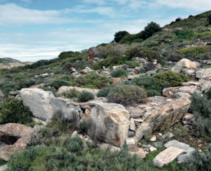
4th-century BC tomb precinct and stele base (left) in the West Necropolis seen from the southwest (photo: JB).
The Geometric, Archaic and Classical cemeteries of Thorikos are located to the north and, probably, to the southeast of the Industrial Quarter and the theatre, their designations deriving from their position vis-à-vis the acropolis (West, South and Southeast necropoleis) and the site’s grid system (Necropolis D1). A fifth cemetery lies south of the theatre. Of the 227 graves found so far, only 135 contained datable material: of these, a large number belong to the Archaic period (7th and 6th centuries BC). The Classical tomb monuments generally fit well into the established typology of late 5th- and 4th-century Attic grave architecture. In the mainly Early Iron Age- and Archaic West Necropolis, four Classical, terraced tomb precincts (periboloi) have been excavated next to a road. Their sculptures include an inscribed and probably once painted stele belonging to a Charinos of Thorikos and his offspring, as well as fragments of marble vases, lekythoi and loutrophoroi – slender vessel forms traditionally associated with the funerary sphere. A stele base completes the picture. Most of these burial zones, lying outside of the residential area (‘Industrial Quarter’), are not visible anymore; only in the West and theatre necropoleis, one can appreciate the architectural remains of the more monumental graves. The cemeteries excavated between 1963 and 1982 seem to form only a faint remainder of the original funerary landscape of Thorikos. Most burials may have been illegally exploited during the 19th and first half of the 20th century AD.
Johannes BERGEMANN, Koen VAN GELDER and Roald DOCTER
Mussche, H., Thorikos. A mining town in ancient Attika (Fouilles de Thorikos. Opgravingen van Thorikos II), Ghent, 1998, 22-29, 40-44.
Mines and Mining
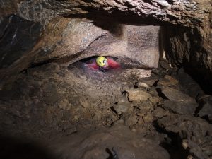
Exploration in the Acropolis Mine
The Lavrion area was the most important mining district of ancient Greece during the 5th and 4th centuries BC. It contains mining works that are among the largest and most spectacular in the ancient world, with shafts reaching 100 metres in depth. The ancient city of Thorikos is part of this territory, deeply marked by the presence of a rich metalliferous deposit (Lead/Silver/Copper). The Velatouri hill has three known major access points underground: the Theatre mine (Mine no. 3) and the Acropolis Mine (Mine no. 6) connected with entrances in the quarry (Mine no. 4) on the southern side, and the Sheepfold Mine (Mine no. 7) located at the foot of the northern side. Some of these mining works are connected with shafts on the slope; they were used for ventilation and extraction. Other sites (Mines nos. 1, 2, 5) correspond a priori to other mining researches. The Velatouri mines have been surveyed since 2013, documenting several periods. The Acropolis Mine is a major site in the general context of the Lavrion with a known extent of nearly 5 km of galleries. The architecture of the galleries, the traces on the walls and finds from these mines (pottery, oil lamps) mainly date to three different periods: Final Neolithic/Early Bronze Age, the second half of the 4th century BC, and the 19th and 20th centuries AD. Mine no. 6 has also yielded evidence for the exploitation of ore resources during the Late Roman period, particularly the 6th and 7th centuries AD. This phase of late antiquity/Byzantine period saw a generalization of firesetting technologies, evinced also in many other mines of the Lavrion.
Denis MORIN
Agios Nikolaos Peninsula

Agios Nikolaos Peninsula
In 1960, the Agios Nikolaos peninsula, named after the church on the summit of the plateau, had been the focus of the first excavations by Herman Mussche, at that time being a Belgian member of the Ecole Française d’Athènes. He investigated the maritime fortress that the Athenians had constructed here in the first year of the 93rd Olympiad (408/407 BC), at the end of the Peloponnesian War. Its strategic position, with two harbours to both sides of the Peninsula and controlling the coastal sea route from the northern Aegean to Cape Sounion, cannot be underestimated. These excavations were swiftly published in the Bulletin de Correspondance Hellenique of 1961. Ceramics that could be dated to the late 5th and 4th century BC seemed to confirm the chronology of the fortifications of Thorikos as suggested by Xenophon (Hellenica I, 2, 1). The fortifications became obsolete in the Hellenistic period, giving way to a metallurgical installation and few graves dug into a now abandoned small gate (poterne C). In 2013, the plateau around the Agios Nikolaos church was investigated by Ghent University with a Ground Penetrating Radar (GPR), yielding indications for the position of the easternmost tower of the fortifications.
Maud WEBSTERThe so-called ‘Demeter Temple’ – The Stoa in the Plain

Stoa in the Plain
In 1754, in the Adami plain below the Velatouri hill, French architect Julien-David Le Roy stumbled upon large, carved blocks of local marble including column drums, and thought he had found the ruin of an ancient temple. In 1813, the British Society of Dilettanti examined it, and concluded that although the building was monumental, it was not a temple but a stoa. The ruins were then investigated by Valerios Staïs for the Greek Archaeological Service in 1893, sounded again by the Belgian School in 1964, and finally fully excavated in the 1990s by Vasileios Petrakos and Maria Oikonomakou for the Greek Archaeological Service. The up-dated plan-maps show a 14.70 x 31.96 m Doric stoa, double-faced and with a central crosswall – a janiform installation, possibly with the function of a propylon. It dates from the last quarter of the 5th century BC, i.e. it seems to have been built during the Peloponnesian War. It may have been part of a special area – a sanctuary, perhaps, or an agora – but the surroundings have not been investigated, and the ancient remains currently lie below c. two metres of alluvial fill. However, it has often been thought that Thorikos may have featured a sanctuary for Demeter, given her importance in the local, ritual calendar and myth, and if there was indeed a sanctuary for her in the Adami plain, then the stoa may represent its entrance. The finds have not, however, either confirmed or denied this hypothesis.
Maud WebsterMiles, M., ‘The vanishing double stoa at Thorikos and its afterlives’, in Autopsy in Athens. Recent archaeological research on Athens and Attika (ed. M. Miles), Oxford 2015, 163-80, for full descriptions and references regarding all previous interventions in the Adami plain.
The Site and its Topography
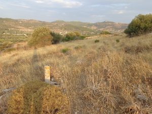
Grid System
Archaeological fieldwork at the site of Thorikos is heavily supported by topographic measurements. Since the start in 1963, three periods can be determined, corresponding with three very important phases in surveying engineering. The first period (1963-1988) is the start of the topographic work at the site and represents the classical land surveying. Optical instruments, like a theodolite in combination with horizontal invar staff and a compass were used. An important legacy of this period is local system, materialized by a 50m x 50m grid with concrete markers. The second period (1989-2005) can be characterized by the introduction of electronic surveying and digital data registration. In this period, total stations and personal computers heavily improved the data- acquisition and processing performance. Another essential development from this period, is the introduction of the Global Navigation Satellite System (GNSS). Since 1997 RTK-GPS (Real Time Kinematic) has been deployed as a portable system for fast point-wise mobile and static data acquisition. Most important, using GNSS, accurate absolute coordinates (called georeferencing) could be assigned to all topographic measurements, and to the materialized grid system in particular. The third and last period (2006-*) is a continuation of digitally acquired spatial data, where various high-tech sensors are deployed in the field, ranging from Ground Penetrating Radar (GPR) to robotic total station measurements and (terrestrial and UAV-based) 3D modelling. The large degree of data integration and the introduction of geomatics as a combination of surveying engineering and geo-information sciences are significant contributions to the research at the archaeological site of Thorikos.
Alain DE WULF and Cornelis STAL
De Wulf A., et al., Analysis of the efficiency in archaeology of GPS satellite surveying versus classical surveying using total stations: Applications in the Thorikos region and on the Pyrgari (Greece), in Vermeulen F. and De Dapper M. (eds), BABESCH Supplementa (5), Leuven, 2000, 197–207; Stal C., et al., Integrating geomatics in archaeological research at the site of Thorikos (Greece). Journal of Archaeological Science 45/May, 2014, 112-125.
Geology
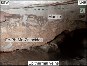
Photographs illustrating the structural position of the Pb-Zn-Fe-Cu-Ag breccia ore deposits from Thorikos enclosed within the upper mylonitic marble just below the detachment fault. The brecciated mineralized level is slightly crosscutting the mylonitic marble and parallel to the low-angle detachment.
The Lavrion area is part of the Attico-Cycladic complex which exposes Tertiary metamorphic rocks formed during the active Alpine convergent system. As for the entire Attico-Cycladic domain, metamorphic rocks, which are mainly made of marble and schists alternations, come from to the metamorphosis of a mainly sedimentary sequence during progressive phases of subduction, syn-orogenic and post-orogenic exhumation between Eocene and Miocene time. The Aegean domain is especially marked by his geodynamic context of orogenic collapse due to Oligocene-Miocene slab retreat responsible for the emplacement of several low-angle detachments that accommodated the exhumation of a Metamorphic Core Complex (MCC). This particular tectonic is responsible for the formation of several base metals (Au-Cu-Pb-Zn-Ag) deposits mainly localised along detachment faults at the all Cycladic scale. The Lavrion peninsula is particularly well known for its historic Pb-Zn-Ag mines exploited since Prehistory until late 20th century with main activity during Antiquity. The Mont Velatouri illustrates perfectly the nappe stack organisation of the entire Lavrion area from the base composed of the mylonitic marble from the lower unit to the top composed of the Lavrion schist from the upper unit, passing through the low-angle detachment and Pb-Zn-Ag mineralised veins and breccias. This geological overview provides an actualised vision in agreement with current geoscientific advancement of the geological and structural context of the nappe stack organisation of the Velatouri area and their relationships with the emplacement of Pb-Zn-Ag deposits.
Christophe SCHEFFER, Alexandre TARANTOLA, Olivier VANDERHAEGHE, Panagiotis VOUDOURIS and Adonis PHOTIADES


